Start from the village of Gargunnock 10km west of Stirling on the A811. You can walk this route for 2miles/3.5km to view Downie's Loup or alternatively, follow a longer route Under the Craigs 4.5miles/7km. Part of this route is across open hillside and it would be advisable to wear good, stout shoes or walking boots like these. From the crossroads in the village, head up Manse Brae, past Moray Place and take the next turning on the right. Make your way up through the sawmill and along the track, past fields and the Dinnin wood until you reach the open hillside.
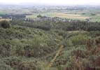
At point-C on the map, turn left and take the path heading into the terraced hills in front of you. On your left you will see the old Dinnin quarry where the path comes to an end.
The quarry was formerly worked for road metal but is now disused . The lava sill which forms the waterfall Downie's Loup on the Gargunnock Burn 300m to the west is also partially exposed in the quarry. Just as you reach the quarry the track narrows somewhat and skirts an outcrop of rock before heading off towards the burn.
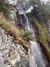
Follow this path across to the burn . About 50m downstream from the barbed-wire fence on your right is Downie's Loup. According to local legend this is named after a horseman who is reputed to have leapt the fall on horseback and may have been killed at the third attempt. The fall is about 10m high and is best approached from below by walking down the edge of the gorse which borders the burn at this point. Be careful at the edge where the burn falls to the chasm floor.When the slope down to the burn becomes gentler, make your way through the bushes to the bottom of the fall.
Further upstream from Downie's Loup there are a series of spectacular waterfalls formed where the burn flows down over the basalt cliffs . An ascent of Carleatheran can be made from the right hand bank of the falls, climbing up the heather-clad slopes and avoiding the rocks. Continue upwards until the ground opens out somewhat into a large grassy shelf . By following the burn upstream you will eventually come upon a quad track heading roughly east-west take and you should take the westerly part.
Although this is not the most direct route it is certainly an easier and drier way of reaching the summit through this often marshy moorland. You will see the trig point of Carleatheran atop a large overgrown burial cairn of some antiquity which overlooks a large expanse of bog. The top makes a great viewpoint especially to the north and west.
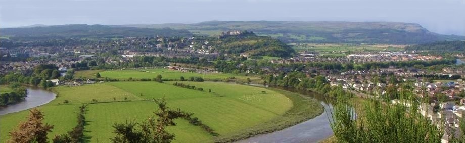
From here you will be rewarded with a stunning view over the Carse of Stirling and the Perthshire hills. The mountains running from West to East are Ben Lomond, Ben Venue, Ben Ledi, Stuc a Chroin and Ben Vorlich.
Now, you can either return to the village or descend to point-C and continue walking under the Craigs.
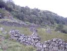
Return to the track and follow it across the Gargunnock Burn. After another 50m, leave the track and follow the orange marker posts up the hill. The route follows an old dry stone dyke and from here you can see Downie's Loup and the old Dinning quarry on the left and get spectacular views over the Carse of Stirling.
The route eventually leaves the course of the old wall. Climb up the hill, across two steep gullies to a stile over a dry stone dyke. Head across the hillside to a track you will see about 1km in the distance. Follow it off the open hillside and down to Knock-o-Ronald Farm.
Take the tarmac road for about 1km until you come to a sharp left turn. Leave the road here and follow the path along the Beeches and back to the village.
Click on an image to see a larger photograph
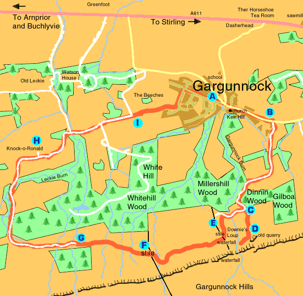
A Start at the Village Inn. Head East to the Square. Turn right at the crossroads and on up Manse Brae.
B Go on past Moray Place taking the next road on the right. Head up through the sawmill and follow the track past fields and woods until you reach the open hillside.
C On clearing the tree line, turn left and take the track which makes directly for the terraced hills in front of you. The Gargunnock Burn tumbles in a series of falls through the cleft on your right.
D The track ends at the old quarry workings.Make for the crest of the grassy skyline which is about 70m to your right for a panoramic view. Take care at the edge where the burn falls 20m to the chasm floor.
E Follow the track across the Gargunnock Burn from point-C. Leave the track and follow the orange marker posts up the hill where the route then follows an old grassed over dry stone dyke.
F The route eventually leaves the course of the old wall. Climb up the hill and across two steep gullies to a stile over a dry stone dyke.
G Make your way across the hillside to this track and follow it down the hillside.
H Follow the track down to Knock-o-Ronald farm then, continue along a tarmac road for 1km.
I Leave the road when you come to a sharp turn to the left and follow a path along The Beeches back to Gargunnock Village.
© In Stirling
With thanks to Stephen Coyne
