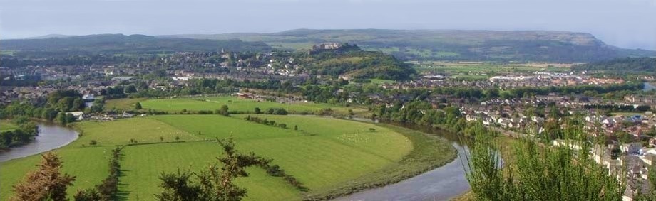
This Baston Burn and Touch Glen walk is only a few miles from Stirling, on the Touch estate near Cambusbarron.
The route can be awkward in places, particularly when making your way up the Baston Burn. It isn't suitable for small children as you will have to climb fences, scramble up banks and if you are not careful, you may get your feet wet. It's worth the struggle and shouldn't present any real problems. There is a shorter route to Gilmour's Linn - see Cambusbarron to Touch Waterfall Walk.
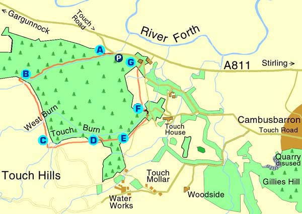
From Stirling, travel along Dumbarton Road to the roundabout at the King's Knot. Proceed along the A811 for about 3 miles (5 kilometres) Turn to the left on to the Touch Road. After a few hundred metres, park in the small layby on the right side of the road (A), where the Baston Burn flows under the road.
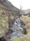
Climb over the fence and start following the burn upstream into the woods. The banks are steep in places and you will have to clamber over fallen trees, rocks and dense undergrowth. There isn't a path to follow and the burn is relatively narrow so, you will find it necessary to keep switching between the banks.
Follow the burn until it takes a sharp turn to the left through a rocky cleft. As you gradually come up out of the trees you will find yourself on a forestry track
(B). Cross over the track, climb the fence and find a way over the burn. Leave the burn here and start heading South along the edge of the woods, following the line of the dry stone dyke.
After a short climb, you can look behind for great views over the River Forth, the Carse and the hills beyond. It can be boggy underfoot and you may have to keep criss-crossing onto higher ground. After about 1.5km you will cross the West Burn and 500m further on will come to the Touch Burn (C).
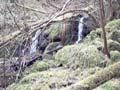
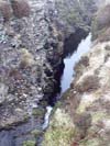
Start heading down on the right of the burn. Be careful near the edge, where the burn cuts through a deep gully in the rock. Make your way over the open field for 1/2mile (3/4 km) until you see a line trees ahead of you. Climb the fence into the woods and follow the low, drystone dyke back towards the burn. Carefully, make your way down the bank and you should be able to find Gilmour's Linn (D). It can be difficult to locate but it's well worth finding this dramatic, overgrown, scenic waterfall which has a deep cave running behind it. Bonnie Prince Charlie is reputed to have hidden here when fleeing after the Battle of Culloden. Care should be taken while descending to the waterfall as the bank is steep and covered in loose material.
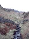
Just along from the waterfall, the burn drops into a deep gorge and the banks become precipitous. Make your way back up the right hand bank and you should be able to find a more defined path. Keep moving along and up, eventually climbing over the fence, into the field (E).
Proceed down the hill, in the direction of the burn. You will see Touch House through the trees ahead of you and get a great view over Stirling and the Ochils. Cross the burn over a well maintained wooden bridge and follow the track on the opposite side (F).
Leave the track as it turns off to the left and continue downhill, walking diagonally towards the white cottage (G), where you can get back on to the Touch Road. Turn left and walk 1/3mile (1/2 km) along the road to get back to the starting point.
A Travelling from Stirling on the A811, turn on to the Touch Road.Park in a layby on the right hand side where the Baston Burn flows under the road.
B Follow the burn up the hill until you come out of the woods.Climb the fence, find a way over the burn and start heading South along the edge of the woods.
C After about 1.5km you will cross the West Burn and 500m further on will come to the Touch Burn
D Make your way over the open field for 1/2mile (3/4 km) until you see a line of trees ahead of you.Climb the fence and follow the drystone dyke back towards the burn.Make your way down the bank to find Gilmour's Linn
E Make your way back up the right hand bank where you will find a more defined path.Walk along and up, climb over the fence and into the field
F Proceed down hill in the direction of the burn.Cross the burn over a well maintained wooden bridge and follow the track on the other side until it turns off to the left
G Continue walking diagonally downhill, towards the white cottage.Walk 1/3mile (1/2 km) to get back to the starting point on the Touch Road.
With thanks to Stephen Coyne.
